
Glacial geomorphology is the study of how glaciers shape the Earth’s surface. It reveals fascinating secrets about our planet’s history and processes. Let’s dive into the world of glacial geomorphology and uncover some of its mysteries.
**What is Glacial Geomorphology?**
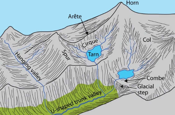
Glacial geomorphology is the study of landforms created by glaciers. These icy giants have the power to shape mountains, valleys, and plains over thousands of years.
**How Do Glaciers Shape the Landscape?**
Glaciers move slowly over the land, carving out valleys and flattening out areas. They can create U-shaped valleys, moraines, and cirques.
**The Legacy of Glaciers**
Glacial geomorphology provides evidence of past glaciation events. By studying these landforms, scientists can piece together the history of our planet’s climate and geological processes.
**Glacial Erratics: Nature’s Puzzle Pieces**
Glacial erratics are large boulders that were transported by glaciers and deposited in new locations. These mysterious rocks can give clues about the path and movements of ancient glaciers.
**Changing Landscapes**
As glaciers retreat due to climate change, they leave behind a mark on the landscape. The study of glacial geomorphology can help us understand how these changes affect ecosystems and communities.
**The Future of Glacial Geomorphology**
With advancements in technology and research, the field of glacial geomorphology continues to expand. Scientists are using tools like satellites and drones to study glaciers from a new perspective.
**In Conclusion**
Glacial geomorphology is a fascinating field that reveals the incredible power of ice on our planet. By uncovering the secrets of how glaciers shape the landscape, we gain a deeper understanding of Earth’s history and ongoing processes.